New Delhi: The Home Ministry issued a notification on Saturday detailing the boundaries of the newly created Union Territories of Jammu and Kashmir, and Ladakh. The notification also results in a new political map of India.
The order comes two days after the nation’s newest union territories were formally created and received their first Lieutenant Governors; Girish Chandra Murmu, the former Union Expenditure Secretary, was sworn in as the first Lieutenant-Governor of Jammu and Kashmir and Radha Krishna Mathur, a former Defence Secretary, was sworn in as the first Lieutenant Governor of Ladakh.
Jammu and Kashmir on Thursday transitioned from a state into the Union Territories of Jammu and Kashmir, and Ladakh — nearly three months after Parliament revoked the state’s special status by abrogating Article 370. On the recommendation of the Parliament, President Ram Nath Kovind effectively abrogated Article 370 from the Indian Constitution and issued the Jammu and Kashmir Reorganisation Act, 2019, in August.
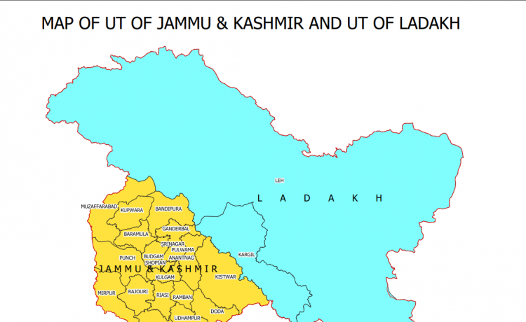
The new map also shows three districts — Muzaffarabad, Punch and Mirpur — which are under Pakistan-occupied Kashmir (PoK).
The Ladakh Union Territory consists of two districts — Kargil and Leh — while the Jammu and Kashmir Union Territory comprises 20 districts.
In 1947, the erstwhile state of Jammu and Kashmir had the following 14 districts – Kathua, Jammu, Udhampur, Reasi, Anantnag, Baramulla, Poonch, Mirpur, Muzaffarabad, Leh and Ladakh, Gilgit, Gilgit Wazarat, Chilhas and Tribal Territory, a home ministry statement said.
By 2019, the government of erstwhile state of Jammu and Kashmir had reorganised the areas of these 14 districts into 28 districts. The names of the new districts were – Kupwara, Bandipur, Ganderbal, Srinagar, Budgam, Pulwama, Shopian, Kulgam, Rajouri, Ramban, Doda, Kishtwar, Samba and Kargil.

